Saturday, July 31, 2010

Thornlie to Perth and Back Again

This is my longest walk and most likely my longest blog to date. I walked today over 30 kilometres and my feet certainly paid for it. I left home at 8:45am and made my way to the end of our road, about 3.5km. From there I took the pathway that went beside the river. After a kilometre there was a footbridge over the river, as the pictures below shows the Canning River looks very nice, although this picture was taken only a few hundred metres from a major shopping centre and a major highway.


The weather once again this Saturday magnificent. After a two hour walk and approximately 12 kilometres I made a slight detour to walk past my childhood home. The house was sold when I was 17. It is interesting  to note how everything feels bigger when you look at the same scene as a kid.
From here to the Causeway was a little over an hours walk. My new shoes were irritating me a little, especially the left foot. It feels like I don’t have enough toe space.

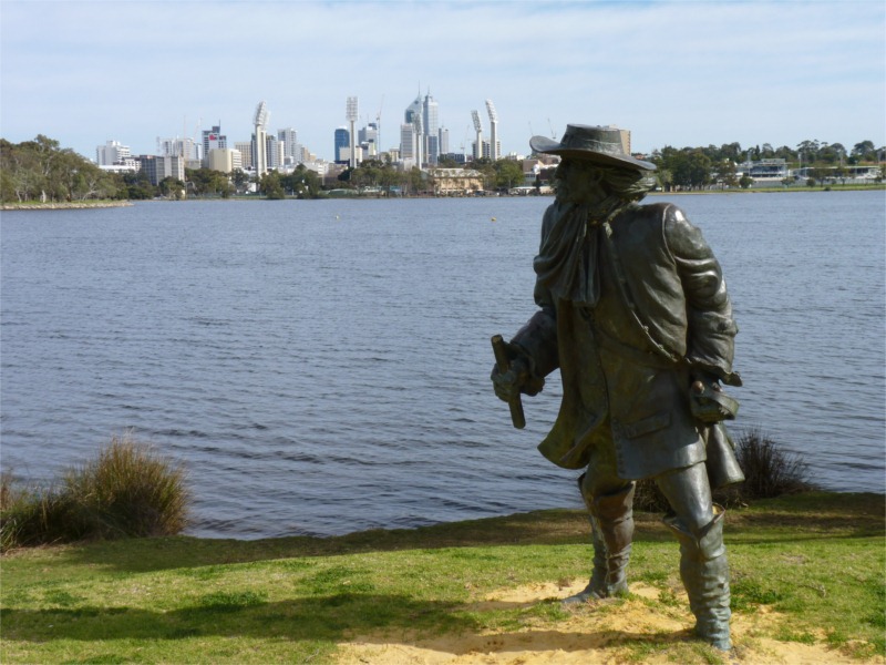
As I walked over the Causeway to the CBD I detoured to walk around one end of Heirrison Island. Heirisson Island was named after French midshipman François-Antoine Boniface Heirisson, who was on the French ship Le Naturaliste which was a scientific expedition led by Nicolas Baudin between 1801 and 1804. The expedition made several journeys up the river from Fremantle in long-boats and made the first maps of the Swan River. The island was named in June 1801. The Causeway is two bridges that cross the Swan river and use Heirrison Island to join the bridges. On one end of the island is stature to remember Yagan who was killed in 1833 by two young farm hands in a treachorous way, Yagan’s head has only recently been returned to Australia after being kept in a British Museum. Unfortunately the stature of Yagan doesn’t look Aboriginal enough.


Just over the Causeway is a lovely garden known as Queens Gardens. They were created in 1899 and this site was once a clay pit which was the source of the bricks for many of the early buildings. In the gardens are  some swans and  their cygnet.
Yagan
Yagan on Heirisson Island


Yagan plaque


Qeens Garden sign

From Queens Gardens it is about a 20 minute walk into the central CBD. My feet were getting fairly tender, but mainly my left foot as my toes feels too squashed. It has taken 3.5 hours to walk into to Perth. Easily 3 hours if I hadn’t had a few detours and stops.
I find by walking it is quite amazing how many different little things you get to notice that you don’t while driving. It would seem to be boring walking so much, but it isn’t. Little things happen all the time to increase the interest. For example on the journey home I was walking past St Mary’s Cathedral and I could hear some Handel music being played. I’m not a great lover of Classical music, but this sound good. I ducked into the cathedral and there was a group of young people involved in a rehearsel. Being played inside a large cathedral the music sounded glorious.
I didn’t particularly enjoy the walk home. I found my left foot really hurting. I put on double socks. This helped for a while then I decided to try no socks on my left foot and that seemed to work well, but I did end up with a blister. One thing I did pass that was interesting was the Community Garden in Victoria Park, I believe a new venture, where people can have their own plot to grow stuff. A great idea. I found walking home along Albany Hyw that it was either car yards, eating places, a large number Indian restuarants and liquor outlets. There was also 4 hotels. There must be an enormous amount of money expended on alcahol. One section of Albany Hyw from Shepparton Rd to Leach Hyw is just an aweful dreary strip.

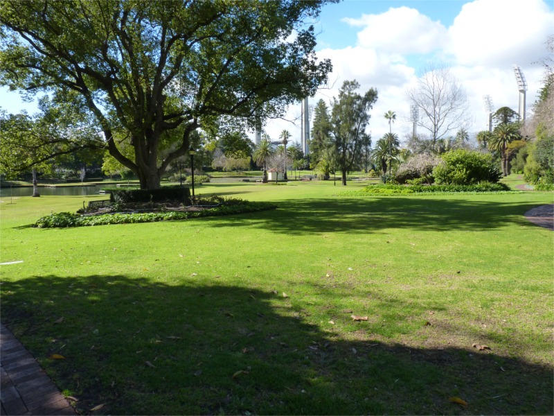
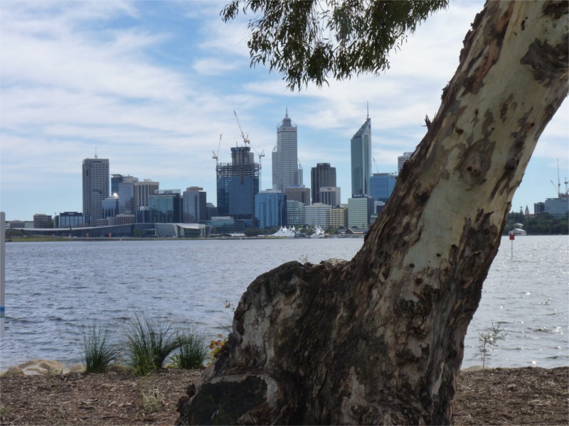
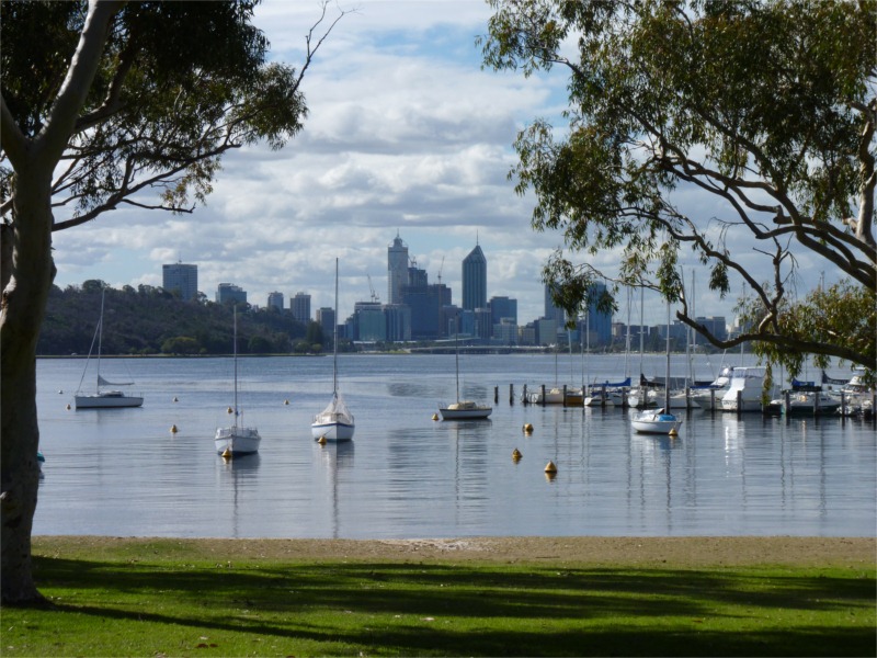
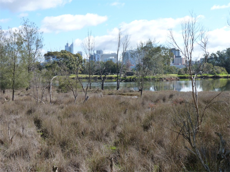
My walks have indicated that there are some beautiful areas and facilities around Perth. The cities looks so prosperous, but as Josh my son told me, we are rated as the third most unsustainable city in the world. Much of our wealth is based on mining. So any turn around there could have dramatic effects.

We have some beautiful parks along our river foreshores, but the reason some of them are there is because we treated the wet area along the river foreshores as areas to dump our rubbish, this was being done up until the 1980s. Some of the rubbish material now leaks into the river. Perth had many natural wetlands, but a large number were filled in as rubbish dumps, or converted to housing estates. I would hate to see what would happen if we had a really wet winter – but it won’t be this year!

I arrived home at 6.15pm. My feet rather sore. I need to see if I can change my shoes for some with more room for the toes. I spent about 1.5  hours in Perth before commencing the walk home. So my walk home was 3.5 hours.

Wednesday, July 28, 2010

New Shoes

Went to the Athlete's Foot today, probably attracted to their computerised system of matching up your foot to a pair of shoes. The sales women also seemed to very quickly identify the type of shoe I would require. Most of my walking is urban, but I also wanted a shoe to do the Cape to Cape walk, but I didn't want a heavy hiking boot.

I was recommended a trail running shoe by ASIC. I haven't spent $190 on a pair of shoes before, but if they do the job and last 2 years I'll be happy. I also puchased a gel liner as this will increase the comfort and enable the shoe to last longer.

This video says something about the shoe, it seems I may have made the right purchase.

Saturday, July 24, 2010

McIver Station to Canning Bridge

This has been my longest walk today, but quite easy as all on good paving. I walked from McIver Train Station, last stop before Perth Station, over the Graham Farmer Freeway Bridge, then along the  Burswood foreshore and then to South Perth. There are several interesting statues on the rivers edge in front of the Burswood Hotel. I stopped off at Mends Street Jetty opposite the City, for an expensive Cappuccino at $4.50, but they did a glass of iced water as well! From there I headed up to towards the Narrows Bridge, probably the narrowest part of the river.

Had a look at the Old Mill South Perth, first established in 1835, it is quite amazing that it has survived destruction, considering the amount of damage they have done in other parts of the city under the banner of development. The Mill wasn’t open until 1.00pm so I kept walking. This last stretch down to Canning Bridge where I first started the walk four Saturdays ago was not that pleasant as I had to keep company with a 6 lane freeway, something they got away with doing in the 60s, but wouldn’t be allowed today. Especially having a major freeway right on the edge of the river. I observed at least have a dozen different bird species, it is amazing how they survive so close to the hub bub of a modern city. As I crossed Canning Bridge I saw a dolphin and its calf moving up the river, my photo only shows the fin of the mother. This last stretch was a distant of over 15 to 18 kilometres. Fortunately the weather was cool, so it wasn't a particularly difficult walk. All up the walk around the river comes to about 55 kilometres and is now concluded, the Perth to Fremantle section at least.

Sunday, July 18, 2010

Freshwater Bay Claremont to Perth

The weather this Saturday we better than last Saturday. The weather was so good it would be difficult to see how it could be any better. I caught the train from Thornlie to Claremont. Kathryn was not joining me for a coffee at the end of this walk. I walked from the Claremont station to Claremont Jetty in Freshwater Bay. After walking out to the end of the Jetty I made my way up the river. There wasn’t a path, but the beach sand was very easy to walk on, and was as good as a path.  Freshwater Bay sweeps around to a limestone headland. This was not too difficult to get around, although I did have to take my shoes off to wade through a small section of water. From here I continued walking through several small bays before making my way around another major headland in the Dalkieth area. There was no footpath and I did have a small section in which I had to take off my shoes and scramble though some fallen branches that were right on the water edge. Fortunately the tide was out, otherwise the walk would have been a little more difficult.

It was not until you started to get towards Nedlands area that an easy path appeared on the foreshore. This path has lights, it would make a pleasant night walk in the evenings – summer time. On the Nedlands foreshore there was a large model plane being flown, very interesting. The river up to this point was very interesting, but from here on there is more seawalls, which detract from the natural feel of the riverscape, starts to give the river a feel of being a drain. Just before Crawley there is Pelican point, one of the few river reserves for migrating and local birds to find sanctuary. Crawley Bay is a very beautiful location. I stopped off at the Crawley Bay Tea Rooms for a coffee. I’m noticing on this walk that my knees are not hurting anymore and I’m handling the walk quite well, so maybe getting into better condition. After the Old Brewery site I
made my way up to Kings Park. A steep walk, but not too difficult. Kings Park has been greatly improved by making the road run run behind the restaurant area, and creating grass between the War Memorial and the shops. I walked to the end of Fraser Avenue and then went down Cliff Street to Jacob’s Ladder, a series of steps that take you back down to Mounts Bay Road. I headed into the CBD as wanted to ask a question at the Apple Supper Store. On the way there I had a look at Bishop House. I noticed the gardens can be accessed, but this must be only on weekdays, as the gates were locked. I obtained some photos of the back of the house.

After having a late Subway lunch and  making my way to the train station I noticed that there was a large number of people peering over the balcony looking down Wellington Street. There was a man the police were after and the streets were closed. This also meant they couldn’t move the trains out of Perth, but they were operating from McIver Station. They recommended that we walk to McIver Station as it could be a long wait. On my way there I went past a Dick Smith store that had wireless printers for $39, a great price. I’m sure they will get there money from the inks. The train from McIver did not go to Thornlie so from Cannington they supplied a bus to Thornlie. So instead of getting home around 3.30pm, it was 5.00pm.

Saturday, July 10, 2010

Fremantle to Freshwater Bay Claremont

Today started off with showers of rain. I wondered if the walk would be a wet one. Kathryn dropped me off at Stirling Bridge Fremantle at about 11.00am. She then drove onto Claremont to wait for me at a Coffee shop. I was expecting this walk to take a little longer due to distance and more difficult terrain.

Opposite Point Walter too hard
North shore of Blackwall Reach, I ran out of footpath
 

The first leg walking over Stirling Bridge followed by a nice walk up the river was very easy. It was great to see how they have made a genuine effort to restore much of the original vegetation, and the foreshore looks much better for there efforts. After a while you get a bit above the shoreline as a cliff face develops. It was interesting walking through Rocky Bay where there are many new homes, as this was where the State Engineering Works was located until 1987 when it was closed. This was where I completed my apprenticeship as a Mechanical Fitter. It is now a very expensive housing area. The area had been made flat as much of the limestone top had been removed to make the groynes at Fremantle Harbour and other building projects around Perth. The path also has some interesting interpretation signs describing flora and local history. In Rocky Bay there use to be a Soap Factory, that building has now been converted into Apartments.
Jetty Blackwall Reach
Hard to believe this part of the river is in the middle of suburbia


The next section was through Blackwall Reach. Most parts there was a track. Instead of diverting from the river at times I walked through the vegetation which joined up with the track further along the river. This did eventually cause me a problem as I eventually ended up being squeezed between the cliff face and the river, one section I took my shoes off and had to get my feet wet. Eventually I made it to a little park on the rivers edge, opposite Point Walter. It was now too difficult to follow the river so I followed the road up the hill and then followed a path down to Mosman Bay and
Peppermint Grove, some great views.
P1030661
Nesting Sea Osprey Peppermint Grove, most expensive suburb in Perth

I continued to follow the shoreline after leaving the Peppermint Grove area. As I was walking through the vegetation I saw a women sitting further along the track, she was taking pictures of some nesting Osprey as part of th book she was writing. She believed the nest they used was over 20 year old. Past this point it become too difficult to walk along the cliff face to the Claremont jetty. Therefore I headed away from the river, walked past Methodist Ladies College and down Stirling Hyw to have a coffee with Kathryn in Claremont. She was a little annoyed as this section had taken about 3.5 hours and the coffee spot was a boring on in a shopping centre. Next week I will continue from Claremont and try to walk as far as Perth.

Saturday, July 3, 2010

Around the River - Pt Walter to Fremantle

Saturday July 3rd Kathryn dropped me off at Pt Walter at 10.00am. She was going to do some shopping in Fremantle and we were to meet either at the E-Shed or the Dome in the Fishing Boat Harbour for a coffee. It sounds repetitive, but the weather was as good as the previous couple of weekends. The only time it has been wet was when I walked from Deep Water Point to Mt Henry Bridge.

The walk along
Blackwall  Reach was quite an experience as it was very natural looking with quite a lot of bird life. Many of the trees had nesting boxes placed in them to encourage the local birds to breed. From what I could observe the Galahs were using the boxes. I was also quite delighted to observe a Sea Osprey (so I think). Blackwall Reach has some useful observation decks and this helps to make a really interesting walk. Also came across the locations where people jump from the cliff for a swim.


Nesting boxes Blackwall Reach Swan River
Looking down river, part of Blackwall Reach


There is a park as you leave
Blackwall Reach which was the site of the Animal Quarantine Station until the early 80s. It is now, or part there of, a beautiful park with barbecue facilities, a lovely beach and a children's play area, some of the area is new housing.
Location of former Animal Quarantine Station


As I was walking towards 
Fremantle there was only one small section that you had to divert away from the river because of one of the yacht clubs. There are some scout groups that have some fantastic sights. The Armies Psychology unit has a magnificent spot on a high pieces of land looking up the river. Just before the new Fremantle Traffic Bridge there is a small waterfall gushing from the cliff face, called Bicentennial Falls. I believe it is based on a natural spring in the area, but it may also be fabricated, as it had a lot of water pouring from it for a very dry winter.


Looking up river towards Blackwall Reach


I met Kathryn in 
Fremantle at the Dome Coffee House at Fisherman's Harbour. While we had lunch and enjoyed the beautiful sunshine and the ambiance we watched a large car carrier ship quite quickly leave the harbour. Before coming home we did a quick trip to the Fremantle Markets to purchase some veggies and fruit.
Kathryn waiting at the Dome Coffee House Fremantle


Another Car Carrier leaves Fremantle Harbour

Around the River - Canning Bridge to Pt Walter

Karen at work gave me the idea to walk all the way around the river in stages. From Canning Bridge to Fremantle, Fremantle to East Perth and then back to Canning Bridge. She is involved in a similar venture.

So on Saturday June 26 Kathryn drove me to Canning Bridge. She then went to Garden City Shopping Centre with a plan to meet me at Pt Walter later in the day. The weather once again was glorious. It was really nice walking around Heathcote Point and the Old Majestic Hotel site, which is now a modern housing sub division. It is great how the general public is not denied access to the river front. There are several plaques along the walk highlighting various significant historical happenings. Even saw quite a few swans in the Alfred Cove area.

Much of the housing along the water edge is so over the top and looks so permanent and secure, but we all know this can change in a very quick period of time. I carry my camera with me as there is always an opportunity to take some pictures from a different perspective when walking. You definitely observe more when you are walking. As I walked the last stretch along the Attadale foreshore Kathryn passed me on her way to the Pt Walter Cafe. The green lawns on the foreshore of Attadale looks very nice, but it is shameful to note that they are there as they used the foreshore originally as a rubbish dump!

The walk took about 2 hours and 15 minutes, approximately 9 kilometres. It could be easily achieved in under 2 hours, but I didn't push my pace too strongly.

Raffles Apartments Canning Bridge


Beach at Heathcote Point
How the river should look at Alfred Cove

Perth CBD Walk - "Icons of Influence"

This is the last of 3 walks around the Perth CBD under the guidance of the downloaded mp3 file. The weather is still outstanding, except for putting water into the dams. Kathryn joined me for the train ride into town. She did her own exploring and waited to have a coffee with me after I had completed the walk.

The walk once again commenced at the Perth Town Hall. The walk predominately looked at locations along St Georges Terrrace as far as the Old Barracks Arch. The Barracks were orginally built to house the soldiers whose duty it was to look after the convicts in the 1850s and 60s. The Arch of the Old Barracks is all that remains, as the bulk of the buildings were removed for the creating of the Mitchell Freeway in the late 1960s.

There was a detour to look at the Weld Club, an excelusive men's club on Barrack street. Not far away is the Karrakata Club, Australia first women's club, established in the early 1900s. Also on St George's Tce there is the WA Club which was established for men in the 1890s, a product of the economic boom from the goldrush in the late 1800s. There wasn't a mineral boom like the goldrush era for WA, until the iron ore developments to the north of the state in the 1960s.

Weld Club - Gentleman's Club

Old Perth Boys Government School

Hale School built by Bishop Hale c1850s. Now know as The Cloisters


Remains of Old Barracks, now just an arch


Perth CBD Walk - "Boom to Bust"

This is the second of 3 walks around the Perth CBD with the assistance of the commentary supplied by the Perth City Council. The "Boom to Bust" walk looked at developments that occured specifically around the the Goldrush period from the early 1890s into the 19th Century. The circuit went from the Perth Town Hall down Barrack Street towards Northbridge and then back to Hay Street Mall. Then along Hay Street Mall to King Street. King Street is largely intact, as many of the buildings were built during the late 1890s and early 1900s. The walk then continued along Murray Street heading towards Forest Chase. The walk concluded at the Perth town Hall. Probably walked in the 3 to 4 km range. After a pleasant walk a coffee is well due. The weather has been unusually dry, but it has meant ideal conditions for walking.
London Court facing onto Hay Street Mall c1930


King Street - now an area of upmarket shops
Perth Mint still producing gold coins c1890s

June Long Weekend 2010

On the first weekend in June we went with friends to stay on some farm chalets just outside of Harvey, a town 150km south of Perth, a major irrigation area for milk production. Harvey Hills Farmstay is in a very beautiful location over looking Harvey Dam. There is also the feeding of farm animals each morning, which was of interest to the little kids and especially Kathryn.

Walk wise, on two mornings I walked from our accomodation to the dam and back, probably a round trip of 3 kilometres at least.

View from our accommodation


My morning walk
A very nice morning