Tuesday, August 31, 2010
Saturday, August 21, 2010
To Tranby House Again
Two Saturdays ago I walked past Tranby House and had lunch there on my way to Guildford. Today I organised for Paul and Glenda to join Kathryn and myself on the 6km walk from East Perth Cove to Tranby House.
We set off at 11.15am and fortunately the sky looked like it wanted to rain on us, but we didn’t get much more than a few drops. The walk was a pretty easy one, we didn’t push ourselves and we arrived at Tranby House at 12.30pm.
They have some fairly fancy High Teas at the Tranby House tea rooms, if you have the two hours to enjoy it. Unfortunately due to the large number of bookings they had they didn’t have the full lunch menu available as they were primarily catering for the High Tea patrons. Kathryn and I settled for the coffee, Paul and Glenda had the scones and cream as well.
We had a fairly well known former state Premier and then Federal MP having a High Tea with her friends at the same time we were there, Carmen Lawrence. A very capable politician, under different circumstances could have had the same opportunities as Julia Gillard our presnet PM.
Next Saturday as I have a bike now, I may ride from Guildford to the Graham Farmer Freeway.
 |
| Enjoying the wildlife on Maylands Peninsula |
 |
| Paul and Glenda intense menu browsing |
Saturday, August 14, 2010
Jarrahwood to Nannup
Friday afternoon Steve and Nola collected us for our drive to Busselton. The traffic on the Kwinana Freeway was quite heavy heading South. The extension of the Freeway to bypass Mandurah certainly made the journey more pleasant than going through Mandurah. On our arrival in Bunbury we had dinner at the Indian Ocean Lounge, an Indian Restaurant. We drove onto Busselton to the Schifferli beach house (my sister and her husband's place)very comfortable accommodation for one night.
Before heading off to Jarrahwood Saturday morning Steve and I made a quick walk to Coles to collect a few supplies for the day. On the way back we came across Damien. He expressed some interest in joining us for the Cape to Cape walk in October.
We arrived at Jarrahwood at about 9:45am. The plan is for Kathryn and Nola to meet us some time after 3.00pm in Nannup. The trail has been created by following the old railway line between Jarrahwod and Nannup. Most of the sleepers have been removed. It is very easy to walk along, except the first section only has a narrow walking section, which makes it difficult to walk two abreast.
The weather was cool with the occasional misty rainfall, no flies, and some of the wildflowers are just getting ready to emerge. Being an old railway line mean the track is very level. There is in some sections a gradual incline or decline. The most senic sections was where the trail crosses St John Brook and the last couple of kilometres leading into Nannup.
The map we had didn’t show enough detail about where we were, based on roads we crossed over. We easily found Cambray Siding, but two other sidings on the track we did not notice that we had passed. We stopped at about 2.00pm for lunch. All up we walked for approximately 5 hours, with 30 minutes added for a few stops and lunch. So we were making about 5 kilomtres and hour. So our walk from Cape to Cape should be based on a similar pace.
The final approach into Nannup is very nice as the old railway bridge passes over the top of the Blackwood River. the water flow was fairly ordinary for this time of the year. We enjoyed using the ablution block built with money from the Royalties for Regions fund. The wooden totems were also quite interesting, depicting various.
Next weekend is the flower festival in Nannup, so there were some nice displays of tulips and daffodils in the main street. We found Kathryn and Nola in one of the local cafes. After have drink we made our way back to Perth via visiting my Aunty Jean at Cundinup. She is 85 this year and looked quite well. We stayed for about 45 minutes and headed off to Perth at 5.00pm. We arrived home at approximately 7.30pm. The leg muscles were quite stiff from the walk, but the feet went well.
 |
| Jarrahwood the commencement of our 26km walk |
 |
| The first railbridge we crossed |
 |
| St John Brook |
 |
| Railbridge in Nannup |
 |
| 3 of 8 totems in Nannup |
 |
| Steve - Nannup Tulips |
 |
| Aunty Jean is doing well for almost 85 years |
Saturday, August 7, 2010
Graham Farmer Freeway to Guildford
Today had a busy start, which delayed my walk, it was a worthwhile cause. Megan wanted assistance in purchasing her first car. She had decided upon a Corolla, I have had 3 of these vehicles, and they are good value. Her budget was $4,000 max. She had checked out some car yards last week and also looking at prices on the Internet. We worked our way through some pretty grundgy car yards and also had a look at one private seller. We found two reasonable looking yards only a couple hundred metres apart with cars that were of interest. One was a 1995 Corolla, fuel injected with 171,000km they wanted $4,900 and wouldn’t accept $3,500. The other Corolla a 1990 model had only done 151,000km, but a carburetor version. It drove nicer than the other car. The original asking price was $4,000, and they sold it to us for $3,000, which I thought was a pretty good price. One happy daughter drove away, and I continued on to my walk destination.
I commenced my walk from the Graham Farmer Freeway bridge, East Perth Cove area at about 1.00pm. It was every bit an 18km walk to Guildford. So far in my walks I have been mainly concentrating on walks along our major rivers, Canning and Swan. In the early days of this colony Fremantle at the mouth of the river was the sea port, 20 km up the river Perth was the major township and then a further 20km up the river Guildford was the inland port. Guildford township is fashioned very much like an English village. In the early days of the colony the wealthy built there home there. As the roads improved or were created and railways were established, Guildford lost its importance as a township.
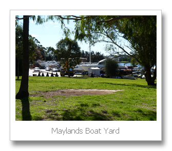
The walk up the river is on the north shore. The combined walking path and cycling track was excellent. The first part of the walk is around the Maylands Peninsula. The Peninsula at one stage was a brickworks and an airfield. Now it is a mixture of lovely housing and a golf course. It does amaze me the way we have abused the river area. We have either dug big clay pits or filled in natural wetlands with our rubbish. Fortunately we have had the wealth to turn the rubbish dump sites into nice parklands and golf courses, but these are not part of the natural environment. As I rounded the peninsula there is a remainder of one of the lights used to illuminate the old airfield. The airfield was used until 1963, when the new airport at Belmont was opened. Although the Belmont site had been used since the 1930s and by the 1960s Maylands was only used for light aircraft. Also on the peninsula is the Maylands boat building facilities. They are still quite extensive and look a little out of place in the middle of suburbia.

After about an hour and a half I was at Tranby House. This historic property is the 3rd farmhouse built on a farm first settled in the 1831. This is the oldest residential building in the Perth area. It was saved from developers to be turned into a heritage property and tea rooms. It really is in a very nice situation. This was about the halfway point of the walk. From here on the river in parts takes on a more natural appearance. There are also some beautiful properties with there own private jetties. One place had a big launch parked out the front, it looked rather unusual so far up the river. Fortunately the pathway mostly followed the river frontage. Occasionally I had to follow the roads inland. As I got closer to Guildford and the older parts of Perth there was reduced access to the river frontage. This would make sense as the early land allocation most likely wouldn’t have taken public access into account.
Another historic site I passed on my walk was a Pensioner Guard House. Build around 1856. This house was provided to retired soldiers who were employed to guard convicts. Once again this is a rare survivor of an earlier era. I made may way across the Guildford Bridge and caught a train back to Claisebrook Station to collect my car. I had arrived in Guildford at about 4.45pm, with 30 minutes lost having afternoon at Tranby House. Therefore the walk took approximately 3 hours and 15 minutes.

 Walking up the river there was 5 bridges. The Graham Farmer Freeway bridge, Tonkin Hyw Bridge, Garrett Rd bridge, Reid Hyw bridge and the Guildford Rd bridge. The older of the Garret Rd bridge my grandfather worked on as a log squarer. As a younger man his employment was squaring jarrah logs to be used as railway sleepers. There was also a lot of people fishing for Bream. The Bream move down the river as the freshwater from winter rains pushes them down the river – not that there has been much rain this year.
 I also failed to mention I changed my shoes during the week to Nike Zoom Equalon +4. These shoes have more toe room, although I preferred the sole of the ASIC shoes. I also feel they may be throwing my feet towards the outside, I will be interested to see how well they wear. At least my toes were in much better condition after this walk. These shoes cost me $260, so I hope I can get a couple years out of them.


I commenced my walk from the Graham Farmer Freeway bridge, East Perth Cove area at about 1.00pm. It was every bit an 18km walk to Guildford. So far in my walks I have been mainly concentrating on walks along our major rivers, Canning and Swan. In the early days of this colony Fremantle at the mouth of the river was the sea port, 20 km up the river Perth was the major township and then a further 20km up the river Guildford was the inland port. Guildford township is fashioned very much like an English village. In the early days of the colony the wealthy built there home there. As the roads improved or were created and railways were established, Guildford lost its importance as a township.
The walk up the river is on the north shore. The combined walking path and cycling track was excellent. The first part of the walk is around the Maylands Peninsula. The Peninsula at one stage was a brickworks and an airfield. Now it is a mixture of lovely housing and a golf course. It does amaze me the way we have abused the river area. We have either dug big clay pits or filled in natural wetlands with our rubbish. Fortunately we have had the wealth to turn the rubbish dump sites into nice parklands and golf courses, but these are not part of the natural environment. As I rounded the peninsula there is a remainder of one of the lights used to illuminate the old airfield. The airfield was used until 1963, when the new airport at Belmont was opened. Although the Belmont site had been used since the 1930s and by the 1960s Maylands was only used for light aircraft. Also on the peninsula is the Maylands boat building facilities. They are still quite extensive and look a little out of place in the middle of suburbia.

After about an hour and a half I was at Tranby House. This historic property is the 3rd farmhouse built on a farm first settled in the 1831. This is the oldest residential building in the Perth area. It was saved from developers to be turned into a heritage property and tea rooms. It really is in a very nice situation. This was about the halfway point of the walk. From here on the river in parts takes on a more natural appearance. There are also some beautiful properties with there own private jetties. One place had a big launch parked out the front, it looked rather unusual so far up the river. Fortunately the pathway mostly followed the river frontage. Occasionally I had to follow the roads inland. As I got closer to Guildford and the older parts of Perth there was reduced access to the river frontage. This would make sense as the early land allocation most likely wouldn’t have taken public access into account.
 |
| Just north of Graham Farmer Bridge East Perth |
 |
| Brickworks Maylands, closed c1980 |
Another historic site I passed on my walk was a Pensioner Guard House. Build around 1856. This house was provided to retired soldiers who were employed to guard convicts. Once again this is a rare survivor of an earlier era. I made may way across the Guildford Bridge and caught a train back to Claisebrook Station to collect my car. I had arrived in Guildford at about 4.45pm, with 30 minutes lost having afternoon at Tranby House. Therefore the walk took approximately 3 hours and 15 minutes.
 |
| Nike Zoom Equalon +4 |
Subscribe to:
Posts (Atom)