Sunday, October 31, 2010
Hills Walk Saturday October 30th 2010
Kathryn and Megan are in Thailand till tomorrow night. I took the opportunity to have dinner with my good friends Tim and Ruth Moore. They live in the Perth "hills", actually a scarpe, not hills, but they look like hills from the coastal plain. After dinner, being a very pleasant evening Tim and I had a walk for about an hour, probably between 5 and 6 kilometres. The walk circuit took in part of the old railway line that is now a major walk, bridle and bike track from the base of the scarp to well in land. This track is part of the railway reserve trails, 59 kilometes or railway turned in a walkway. Another great walk with a friend.
Tuesday, October 19, 2010
Cape to Cape Day 7 Cosy Corner to Cape Leeuwin
Today is the last leg of the walk. Last legs should be the key word. I have found myself tired the last two days. The walk on Wednesday close to 30km seems to have used all my reserves up. Steve is the Alpha male as he seems to have boundless energy.
We departed from Cosy Corner at around 8:40am. We had a short half hour walk through the coastal heath before we came onto the beach. The beach area was quite interesting as one half of the Cosy Corner beach is a low limestone ledge that when the sea has a large enough swell would have many active blowholes. Many sections of the ledges are collapsing into the sea.
On the next headland we came across two women in their 30s who had done in 5 days what had taken us 7! Their husbands were looking after their children, and they were collected each evening, just like we were. The next major beach was Deepdene. A very long and beautiful beach. It took about 75 minutes to walk the beach, most of it being quite firm to walk on except the last 15 minutes of walking. While trying to walk on the firmer sand close to the water edge I managed to get my shoes soaked, not a nice experience.
By morning tea time we caught up with the tour party at the south end of Deepdene beach and the beginning of a long rock ledge. From the Deepdene beach we could see just and faintly, Leeuwin Lighthouse. Unfortunately we turned off the beach too early, stumbling across what is planned as a track alteration and we walked well inland on a four wheel drive track, ascending to a great height, and breathless, before we realised we had become lost. This little adventure probably cost us 45 minutes of time, and much energy. Meanwhile we returned to the beach and continued along the rock ledge, ascending from the beach front to have lunch at a lookout, joining the the large walking party for lunch. We could now clearly see the lighthouse in the distance. Just before we departed leaving the main group behind, we heard their tour leader saying that the Cumberland rocks offshore were the antipods to Washington. rather interesting.
We then had a short walk, up an incline to a ridge that took us through some quite high coastal heath. We were about 8 km walking distance from the lighthouse. Probably in a straight line it was barely 6 kms away. It became very obvious as we got close to the lighthouse that the vegetation was becoming softer and lusher, an indication of an increased rainfall. Cape Leeuwin averages just under 1000mm of rain per year.
For the last kilometre we ended back on the beachfront. We came across the book registration location and Steve signed us off. On one of the last beaches we crossed it had freshwater dripping from the cliff face at a steady rate. We both filled up one our water bottles and it tasted pretty good. After completing the last beach and visiting the lime encrusted water wheel we walked up to the lighthouse coffee shop to meet Kathryn and Nola. This was the first time we were late, arriving at 2.30pm, when we estimated 2.00pm. We would have been early if it had not been for getting lost for a short while. After a drink and obtaining our certificates for completing the walk I felt very tired but satisfied that we had completed the journey.
Cape to Cape Day 6 Booranup Forest to Cosy Corner
So far I feel yesterday’s walk was the most challenging. Today we arrived at our starting point in the Booranup Forest at 9:20am. The start of the walk was very easy, we made good time through an easy track in the midst of the Karri Forest. After 30 minutes the track turned towards the coast and the Karri’s were soon left behind. The track started to become an up and down walk over the coastal heath. After about 90 minutes we made it to the beach. The large tour group we catch up with each day was just in front of us on the beach.
The beach walk was a long one into Hamelin Bay. The beach walk was about 6 kilometres long not all that difficult as the sand was quite firm. It was a glorious day and we made good time. I had a chat with one of the ladies on the tour group and she explained that the walk was very enjoyable and well organised. We arrived at the Hamelin Bay settlement at about twelvish. The seabreeze came in as we had our lunch overlooking the beautiful waters.
After lunch we made our way along another small beach for about 20 minutes before the track turned inland. The walk inland was quite challenging over quite steep hills. After a strenuous and demanding walk we reached a small lighthouse referred to as Foul Bay Lighthouse. The view from the lighthouse location was beautiful. It was an easy 15 minute walk to Cosy Corner road for our pickup. We will start from this location for our last part of the walk tomorrow.
Cape to Cape Day 5 Prevally Park to Booranup Forest
We are into a regular routine. We all arise between 6:30am and 7:00am. after breakfast and final preparations for the days walk completed, we usually arrive at our starting point at 9:00am.
Today we headed off from Prevally Park (mouth of Margaret River), the walk initially went behind the township and quite some distance inland. This was to be a long walk at 26 plus kilometres. After skirting the township we ended eventually on the beachfront. Today was particularly beautiful, the most consistent day weather wise we have experienced.
After about an half hour of up and downs through relatively easy walking country we came to a very steep descent, about 300 steps down to the valley of a brook. The large tour group we catch up with each day were having their morning tea in a nice area shady area next to the brook.
We then followed the brook until it reached the ocean. We had a quite strenuous walk on the beach. the sand was quite soft, so it was hard work for an hour. We stopped at one location to watch these very small birds on the water edge running down to the water edge to feed on small somethings that the water washed in. It was quite humorous watching the birds running up and down the beach avoiding the waves.
When we cleared the soft beach section we had lunch at a place called Redgate Beach. The seabreeze had come in so the temperature had dropped a little. After another short beach walk we headed inland again with most of the walk being along the coastal ridge. the views were spectacular at times. This was a long walk through the bush, the low scrub was quite scratchy on the legs. At about 2.10pm we arrived at a place called Contos. From here it was another hour and half walk through four wheel drive tracks and some patches of Karri forest, quite a nice walk. We arrived at our pickup spot on the time we had planned at 4.00pm.
Cape to Cape Day 4 Grace Town to Prevally Park
Another close to 9.00am start. We were dropped off at Grace Town on the south side of the bay. After the usual photo session at the commencement of each day, we headed south. The weather very quickly looked like it was going to be unpleasant. There was some very dark clouds and a strong wind blowing. We donned our red ponchos, which are now starting to get very tacky. There was a lot of wind but not much rain, and the weather soon improved.
Much of our walk was along sandy paths. About 5kms into the walk we turned inland to Ellenbrook Homestead. I believe this was the home of Georgina Bussell. A very nice grass area was around the house. Although not far from the coast it was well protected from the prevailing winds. The walk then headed further inland to where a freshwater stream appeared from underneath a limestone outcrop, quite unusual, but very attractive. The walk then followed an old four wheel drive track further inland. It was worthwhile seeing some of the different wild flowers, how they varied from the coastal flowers. After about an hour of walking inland, the track made its way to the coast again.
As we headed along the coast again the weather came in bad, we headed for a clump of tea trees to shelter in to have our lunch while the weather passed over. After we emerged from our Tea Tree bushes the weather had cleared. The rest of the walk was mainly along the coastline. The wind was blowing very strongly as we made our way into Prevally Park. Fortunately we made our way across the river mouth easily as the sand bar was not open. We arrived at 2.00pm an hour ahead over schedule again. Tomorrow is our longest stretch at 26km.
Cape to Cape Day 3 Moses Rock to Grace Town
By the end of today I had a blister on my left and right big toe. We arrived at Moses Rock at about 8:50am. Unfortunately the weather today was not as pleasant initially as we expected. There was a drizzly mist for the first couple hours we walked. The disposable red ponchos I had bought some time ago came in very handy. When we passed the tour group with 15 walkers they referred to us as Russell and Russell!
We haven’t met a lot of people on the track. Today we saw a family group with mum and dad carrying large packs and the two boys with day packs. They had been on the track for 5 days, making their way north. There is not a lot of people who do the walk from South to North. The other two groups we have encountered are the 15 people who are part of Inspiration Tours and about 6 people who are walking on behalf of Mental Health Week, or something like that.
The family group we encountered encouraged us to walk around the base of Willyabrup Cliffs, indicating it was one of the more attractive parts of the walk. It was a little tricky making our way around the cliff face, the views were fantastic. In one spot there were workers working on a pathway below the area where they do abseiling. In my wisdom I said to them as joke, “how many years will you be cracking rocks”. It wasn’t until I had walked past one of the bosses and noticed that he had on his lapel, “Corrective Services”, that I realized this were real life inmates working on a community project! Steve could hardly stop himself from laughing.
As the day wore on the weather lifted and it turned out to be a very beautiful day. We had lunch in a rocky bay called Whaleback Bay. After lunch we had a walk for about one more hour to reach Gracetown. We arrived about 1.50pm and had to wait till shortly after 3.00pm for Nola and Kathryn to pick us up. While we were waiting we enjoyed watching the surfers in the bay, especially those on rather large boards who paddle out to the wave, even using the paddle once they catch the wave.
Cape to Cape Day 2 Yallingup to Moses Rock
We commenced today at about 9.30am. The walk today is a little further, being 16 kilometres long. The walk was not too hard to take except when walking along the beach stretches or up and down sand dunes. Fortunately the sand stretches are not too long.
The wind was not as strong as yesterday afternoon. It really helps to wear a wide brimmed hat to keep the sun off your face, although my legs are getting a little over cooked. I also ended up with a blister on my right big toe. A bandaid on the toe and an extra pair of socks and my toe went well for the rest of the day.
There is an enormous amount of wildflowers that we had the pleasure of photographing. The scenery is very variable, frequently changing from cliff to beach, so it never becomes boring. Just before Moses Rock was reached we crossed over Quindalup Creek and in the background was the falls, we could not see much water going over the falls. It looked very soft sand up to the base of the falls, so we gave it a miss. It was bad enough walking up the soft sand path as we moved away from Quindalup Creek. The area has red “ocre”, so was a traditional aboriginal area for corroborees.
The photos tell more of a story than the words I write. We arrived at Moses Rock our meeting point at 2.50pm. Kathryn and Nola arrived about 10 minutes later.
Saturday, October 9, 2010
Day 1 Cape Naturaliste to Yallingup
The day of the big walk has arrived. Steve and Nola collected us at 10.00am. The drive to Cape Naturaliste was a little over 3 hours. The traffic was quite heavy as this is the school holiday period, being Saturday many people would be commencing their holidays.
After lunch on the Busselton foreshore we made our way to Cape Naturaliste a short drive away. We commenced our walk at Approximately 2.00pm. The first leg was to Sugarloaf Rock, approximately 3 kms away. This was really easy as the walk trail is sealed, making it possible for those in wheel chairs to enjoy a short part of the walk.
There was many wild flowers, mainly in pinks, whites and purples to observe as we walked along. We passed one group of about 7 back packers, as they were carrying large packs we soon overtook them. I’m glad we only had to carry day packs as the sandy strips would become quite difficult walking with a heavy pack.
After we passed Sugarloaf Rock we were onto the sand tracks, which in some spots were quite soft. At times you walked on the ledge above the beach, other times there was small sections of beach walking. It was all very pleasant except for the quite strong wind, at least it wasn’t too hot. We also had a brief but pleasant encounter with Ray who was one of the authors of the guide book we were using. He was in the process of developing the 5th edition of the book. Steve said he was aware of him as a science teacher, although he was now obviously retired.
We saw some fauna, two kangaroos, nice red ones, they bounded away as we got near to them. Also saw a small goanna on the track, which didn’t move at all, maybe it was too cold. Also saw a beautiful Blue or Splendid Wren, tried to get a photo, but it was a little blurred.
The final stretch into Yallingup was along the beautiful Yallingup Beach, completing.approximately 14km on our first day, a 3.5 hour walk. We arrived in the car park at 5.30pm, Kathryn and Nola were waiting to take us back to Taunton Farm. Tomorrow we make our way from Yallingup to Moses Rock, approximately 17.5km.
Saturday, September 25, 2010
Cape to Cape Track 1
Cape to Cape Track 1
This is a good overview provided by someone eles's walk diary. It is quite amazing how much the scenery changes.
This is a good overview provided by someone eles's walk diary. It is quite amazing how much the scenery changes.
Port Beach to Cottesloe Beach
Today was another magnificent day, weatherwise. I have been so fortunate that most of my Saturdays have been great days weatherwise. I'm sure very soon that the warmer weather will take the edge of the joy. As the Cape to Cape walk commences next Saturday I thought it would be wise to get some sand walking done before hand. Therefore I parked the car at Port Beach and walked along the beach as much as possible to Cottesloe Beach. Probably about 4 kilimtres of beach sand, with the occasional groyne or rocky headland in the way.
The weather was ideal with a gentle breeze blowing. I was surprised how well I walked in the sand, even the sand that was quite soft. I must be slowly getting fitter. Between Port Beach and Cottesloe Beach there is a great dog beach. Dogs everywhere, I'll have to bring our Lucy here during the week. It took me about an hour to walk to Cottesloe Beach, which is always a nice area, with the lawns that are there. We really do have magnificent beaches, probably there only downside is the water is not warm like it is on some tropical beaches or even on the east coast of Australia.
After enjoying a coffee observing the beach I made my way back to care via the footpath. When I go back on Monday I'll try to walk both directs in the sand.
 | |||
| Indiana Tearooms Cottesloe Beach |
 |
| Looking north to Cottesloe Beach |
 |
| Looking south to Fremantle - dog beach in the foreground |
Thursday, September 23, 2010
Sunday, September 19, 2010
Riding
After a bit of a break from the weekly long walk I had a long bike ride rather than a walk, partly because some or my walk were taking up too much of my time on Saturdays. Walking is still a more enjoyable pursuit.
Caught the train with bike just after 8.00am. Disembarked at Claisebrook Station and took the cycleway that runs along the Midland railway line. This cycle path is continuous until a little before Bassendean, where you have to continue on Guildford Road. The road was pleasant from a commuting point of view, but not a lot to see. Also the Summer easterly winds have started so it was a matter of constantly pushing against the wind.
The ride to Guildford bridge only took about 40 minutes. After heading south along the Swan River, and at the Guildford end there is no trail along the rover on the South bank, therefore I had to follow the main road initially. After crossing over the Helena River which enters the Swan just south of Guildford, I took a detour and visited George and Barb Hawkins.
When I recommenced the my ride south just before entering Great Eastern Highway a bicycle track commences which very quickly takes you to Garvey Park, which now has a kiosk on the water edge, and appropriate spot to have a coffee. From here the bike track follow the river until Garratt Road Bridge. The bike track stops here and you have sort of ride around Ascot Waters subdivision and then the bike track commences again, and it continues without a break until eventually I reached the Claisebrook Station for the train ride home.
My ride would have to be in excess of 20 kilometres and this obviously was covered a lot quicker than I could do walking. I've now covered as much as possible all the river banks from Guildford to Fremantle, it is surprising how much of the river side is accessible to the general public.
 |
| Looking towards Perth from some high ground Belmont area |
 |
| Remains of the old brickworks -Belmont |
 |
| Looking down river to Garratt Road Bridge |
 |
| Kiosk Garvey Park |
Sunday, September 12, 2010
Slipping
Well I really feel I'm slipping with my longer weekend walks at the moment. I was planning on a bike ride from Guildford to Perth on the south shore. I have walked the northern shore already. Only problem was i have had a terrible tooth pain this week, most likely a nerve problem. Voltaren has brought the pain under control, but I was a bit cautious about a walking or riding with a sore tooth. Although I did manage to go for a ride bike this Sunday afternoon for a little over an hour. Did a loop using the bike/walk path along the Canning River. Went from Thornlie to Kent Street Weir crossing over at the weir and returning on the other side of the river. The river looked quite nice this time of the year, especially with water flowing over the weir. There is also a few viewing platforms they have recently built for viewing the river and bird life. Next weekend I hope to complete my Guildford ride and then for some beach walking to better prepare myself for the Cape to Cape walk.
Sunday, September 5, 2010
Not so this weekend
Well this weekend I failed to get a decent walk done. There was a wedding on Saturday, so the best I achieved was a walk this evening. Next Saturday I plan to complete a bike ride from Guildford to East Perth Cove on the South side of the river, I've already walked the north side. And then I need to do a couple beach walks to help prepare for the Cape to Cape walk in October!
Thursday, September 2, 2010
Adelaide
Yes you are correct Adelaide is not part of Perth. If it was an outer suburb it would be 2700km from the Perth CBD. Last weekend August 27 to 29 Kathryn and I flew to Adelaide for a conference I was to attend on the Saturday.
We stayed with our friends Isaac and Wendy who have house that overlooks the Torrens River Linear Park. There was actually water flowing doen the Torrens, which usually resembles a creek! It seems that the winter rains we have missed out on have been gained by South Australia and Vistoria.
My intention was to walk the 10km into Adelaide on the Saturday morning. I arose too late so settled for the 15 minute walk through the Linear Park to Paradise O-Bahn interchange, and then a 15 minute work to the Adelaide Christadelphian Hall for the conference. This Hall is in the Adelaide CBD. So all up I had about an hours walk for the day. I'm surprised the O-Bahn idea of busses running upto 100km on their own concrete tracks has not caught on elsewhere in the world. It is unique to Adelaide's 12km of track and one other track in Germany.
Many people criticise Adelaide as a city, but I always enjoy the feel of the place when I give it a visit. The architecture is quit interesting. Many grand house and building were built in Adelaide before Perth had any money to really develop. Adelaide these days is over shadowed by Perth, but Perth has very few classy late 18th century homes that Adelaide has. The city is also quite attractive as it was well laid out with wide streets in the CBD. They also had no convicts like the rest of the Australian capital cities.
It looks like next weekend I won't get much of a walk in as there is a wedding to attend Saturday, we will see Isaac and Wendy again as they are over for the wedding.
 | |||
| Linear Park Torrens River (note water) on way to Paradise Interchange |
 |
| View form Isaac and Wendy's house |
 |
| Tram in Adelaide CBD |
 |
| Adelaide Christadelphian Hall - referred to as the Temple |
 |
| An 18th Century duplex, typical Adelaide style |
Tuesday, August 31, 2010
Saturday, August 21, 2010
To Tranby House Again
Two Saturdays ago I walked past Tranby House and had lunch there on my way to Guildford. Today I organised for Paul and Glenda to join Kathryn and myself on the 6km walk from East Perth Cove to Tranby House.
We set off at 11.15am and fortunately the sky looked like it wanted to rain on us, but we didn’t get much more than a few drops. The walk was a pretty easy one, we didn’t push ourselves and we arrived at Tranby House at 12.30pm.
They have some fairly fancy High Teas at the Tranby House tea rooms, if you have the two hours to enjoy it. Unfortunately due to the large number of bookings they had they didn’t have the full lunch menu available as they were primarily catering for the High Tea patrons. Kathryn and I settled for the coffee, Paul and Glenda had the scones and cream as well.
We had a fairly well known former state Premier and then Federal MP having a High Tea with her friends at the same time we were there, Carmen Lawrence. A very capable politician, under different circumstances could have had the same opportunities as Julia Gillard our presnet PM.
Next Saturday as I have a bike now, I may ride from Guildford to the Graham Farmer Freeway.
 |
| Enjoying the wildlife on Maylands Peninsula |
 |
| Paul and Glenda intense menu browsing |
Saturday, August 14, 2010
Jarrahwood to Nannup
Friday afternoon Steve and Nola collected us for our drive to Busselton. The traffic on the Kwinana Freeway was quite heavy heading South. The extension of the Freeway to bypass Mandurah certainly made the journey more pleasant than going through Mandurah. On our arrival in Bunbury we had dinner at the Indian Ocean Lounge, an Indian Restaurant. We drove onto Busselton to the Schifferli beach house (my sister and her husband's place)very comfortable accommodation for one night.
Before heading off to Jarrahwood Saturday morning Steve and I made a quick walk to Coles to collect a few supplies for the day. On the way back we came across Damien. He expressed some interest in joining us for the Cape to Cape walk in October.
We arrived at Jarrahwood at about 9:45am. The plan is for Kathryn and Nola to meet us some time after 3.00pm in Nannup. The trail has been created by following the old railway line between Jarrahwod and Nannup. Most of the sleepers have been removed. It is very easy to walk along, except the first section only has a narrow walking section, which makes it difficult to walk two abreast.
The weather was cool with the occasional misty rainfall, no flies, and some of the wildflowers are just getting ready to emerge. Being an old railway line mean the track is very level. There is in some sections a gradual incline or decline. The most senic sections was where the trail crosses St John Brook and the last couple of kilometres leading into Nannup.
The map we had didn’t show enough detail about where we were, based on roads we crossed over. We easily found Cambray Siding, but two other sidings on the track we did not notice that we had passed. We stopped at about 2.00pm for lunch. All up we walked for approximately 5 hours, with 30 minutes added for a few stops and lunch. So we were making about 5 kilomtres and hour. So our walk from Cape to Cape should be based on a similar pace.
The final approach into Nannup is very nice as the old railway bridge passes over the top of the Blackwood River. the water flow was fairly ordinary for this time of the year. We enjoyed using the ablution block built with money from the Royalties for Regions fund. The wooden totems were also quite interesting, depicting various.
Next weekend is the flower festival in Nannup, so there were some nice displays of tulips and daffodils in the main street. We found Kathryn and Nola in one of the local cafes. After have drink we made our way back to Perth via visiting my Aunty Jean at Cundinup. She is 85 this year and looked quite well. We stayed for about 45 minutes and headed off to Perth at 5.00pm. We arrived home at approximately 7.30pm. The leg muscles were quite stiff from the walk, but the feet went well.
 |
| Jarrahwood the commencement of our 26km walk |
 |
| The first railbridge we crossed |
 |
| St John Brook |
 |
| Railbridge in Nannup |
 |
| 3 of 8 totems in Nannup |
 |
| Steve - Nannup Tulips |
 |
| Aunty Jean is doing well for almost 85 years |
Saturday, August 7, 2010
Graham Farmer Freeway to Guildford
Today had a busy start, which delayed my walk, it was a worthwhile cause. Megan wanted assistance in purchasing her first car. She had decided upon a Corolla, I have had 3 of these vehicles, and they are good value. Her budget was $4,000 max. She had checked out some car yards last week and also looking at prices on the Internet. We worked our way through some pretty grundgy car yards and also had a look at one private seller. We found two reasonable looking yards only a couple hundred metres apart with cars that were of interest. One was a 1995 Corolla, fuel injected with 171,000km they wanted $4,900 and wouldn’t accept $3,500. The other Corolla a 1990 model had only done 151,000km, but a carburetor version. It drove nicer than the other car. The original asking price was $4,000, and they sold it to us for $3,000, which I thought was a pretty good price. One happy daughter drove away, and I continued on to my walk destination.
I commenced my walk from the Graham Farmer Freeway bridge, East Perth Cove area at about 1.00pm. It was every bit an 18km walk to Guildford. So far in my walks I have been mainly concentrating on walks along our major rivers, Canning and Swan. In the early days of this colony Fremantle at the mouth of the river was the sea port, 20 km up the river Perth was the major township and then a further 20km up the river Guildford was the inland port. Guildford township is fashioned very much like an English village. In the early days of the colony the wealthy built there home there. As the roads improved or were created and railways were established, Guildford lost its importance as a township.
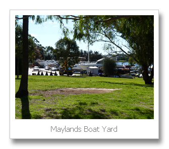
The walk up the river is on the north shore. The combined walking path and cycling track was excellent. The first part of the walk is around the Maylands Peninsula. The Peninsula at one stage was a brickworks and an airfield. Now it is a mixture of lovely housing and a golf course. It does amaze me the way we have abused the river area. We have either dug big clay pits or filled in natural wetlands with our rubbish. Fortunately we have had the wealth to turn the rubbish dump sites into nice parklands and golf courses, but these are not part of the natural environment. As I rounded the peninsula there is a remainder of one of the lights used to illuminate the old airfield. The airfield was used until 1963, when the new airport at Belmont was opened. Although the Belmont site had been used since the 1930s and by the 1960s Maylands was only used for light aircraft. Also on the peninsula is the Maylands boat building facilities. They are still quite extensive and look a little out of place in the middle of suburbia.

After about an hour and a half I was at Tranby House. This historic property is the 3rd farmhouse built on a farm first settled in the 1831. This is the oldest residential building in the Perth area. It was saved from developers to be turned into a heritage property and tea rooms. It really is in a very nice situation. This was about the halfway point of the walk. From here on the river in parts takes on a more natural appearance. There are also some beautiful properties with there own private jetties. One place had a big launch parked out the front, it looked rather unusual so far up the river. Fortunately the pathway mostly followed the river frontage. Occasionally I had to follow the roads inland. As I got closer to Guildford and the older parts of Perth there was reduced access to the river frontage. This would make sense as the early land allocation most likely wouldn’t have taken public access into account.
Another historic site I passed on my walk was a Pensioner Guard House. Build around 1856. This house was provided to retired soldiers who were employed to guard convicts. Once again this is a rare survivor of an earlier era. I made may way across the Guildford Bridge and caught a train back to Claisebrook Station to collect my car. I had arrived in Guildford at about 4.45pm, with 30 minutes lost having afternoon at Tranby House. Therefore the walk took approximately 3 hours and 15 minutes.

 Walking up the river there was 5 bridges. The Graham Farmer Freeway bridge, Tonkin Hyw Bridge, Garrett Rd bridge, Reid Hyw bridge and the Guildford Rd bridge. The older of the Garret Rd bridge my grandfather worked on as a log squarer. As a younger man his employment was squaring jarrah logs to be used as railway sleepers. There was also a lot of people fishing for Bream. The Bream move down the river as the freshwater from winter rains pushes them down the river – not that there has been much rain this year.
 I also failed to mention I changed my shoes during the week to Nike Zoom Equalon +4. These shoes have more toe room, although I preferred the sole of the ASIC shoes. I also feel they may be throwing my feet towards the outside, I will be interested to see how well they wear. At least my toes were in much better condition after this walk. These shoes cost me $260, so I hope I can get a couple years out of them.


I commenced my walk from the Graham Farmer Freeway bridge, East Perth Cove area at about 1.00pm. It was every bit an 18km walk to Guildford. So far in my walks I have been mainly concentrating on walks along our major rivers, Canning and Swan. In the early days of this colony Fremantle at the mouth of the river was the sea port, 20 km up the river Perth was the major township and then a further 20km up the river Guildford was the inland port. Guildford township is fashioned very much like an English village. In the early days of the colony the wealthy built there home there. As the roads improved or were created and railways were established, Guildford lost its importance as a township.
The walk up the river is on the north shore. The combined walking path and cycling track was excellent. The first part of the walk is around the Maylands Peninsula. The Peninsula at one stage was a brickworks and an airfield. Now it is a mixture of lovely housing and a golf course. It does amaze me the way we have abused the river area. We have either dug big clay pits or filled in natural wetlands with our rubbish. Fortunately we have had the wealth to turn the rubbish dump sites into nice parklands and golf courses, but these are not part of the natural environment. As I rounded the peninsula there is a remainder of one of the lights used to illuminate the old airfield. The airfield was used until 1963, when the new airport at Belmont was opened. Although the Belmont site had been used since the 1930s and by the 1960s Maylands was only used for light aircraft. Also on the peninsula is the Maylands boat building facilities. They are still quite extensive and look a little out of place in the middle of suburbia.

After about an hour and a half I was at Tranby House. This historic property is the 3rd farmhouse built on a farm first settled in the 1831. This is the oldest residential building in the Perth area. It was saved from developers to be turned into a heritage property and tea rooms. It really is in a very nice situation. This was about the halfway point of the walk. From here on the river in parts takes on a more natural appearance. There are also some beautiful properties with there own private jetties. One place had a big launch parked out the front, it looked rather unusual so far up the river. Fortunately the pathway mostly followed the river frontage. Occasionally I had to follow the roads inland. As I got closer to Guildford and the older parts of Perth there was reduced access to the river frontage. This would make sense as the early land allocation most likely wouldn’t have taken public access into account.
 |
| Just north of Graham Farmer Bridge East Perth |
 |
| Brickworks Maylands, closed c1980 |
Another historic site I passed on my walk was a Pensioner Guard House. Build around 1856. This house was provided to retired soldiers who were employed to guard convicts. Once again this is a rare survivor of an earlier era. I made may way across the Guildford Bridge and caught a train back to Claisebrook Station to collect my car. I had arrived in Guildford at about 4.45pm, with 30 minutes lost having afternoon at Tranby House. Therefore the walk took approximately 3 hours and 15 minutes.
 |
| Nike Zoom Equalon +4 |
Saturday, July 31, 2010
Thornlie to Perth and Back Again
This is my longest walk and most likely my longest blog to date. I walked today over 30 kilometres and my feet certainly paid for it. I left home at 8:45am and made my way to the end of our road, about 3.5km. From there I took the pathway that went beside the river. After a kilometre there was a footbridge over the river, as the pictures below shows the Canning River looks very nice, although this picture was taken only a few hundred metres from a major shopping centre and a major highway.

The weather once again this Saturday magnificent. After a two hour walk and approximately 12 kilometres I made a slight detour to walk past my childhood home. The house was sold when I was 17. It is interesting to note how everything feels bigger when you look at the same scene as a kid.
From here to the Causeway was a little over an hours walk. My new shoes were irritating me a little, especially the left foot. It feels like I don’t have enough toe space.
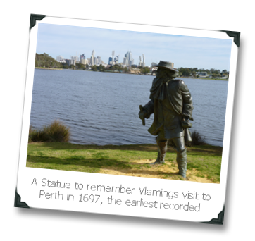
As I walked over the Causeway to the CBD I detoured to walk around one end of Heirrison Island. Heirisson Island was named after French midshipman François-Antoine Boniface Heirisson, who was on the French ship Le Naturaliste which was a scientific expedition led by Nicolas Baudin between 1801 and 1804. The expedition made several journeys up the river from Fremantle in long-boats and made the first maps of the Swan River. The island was named in June 1801. The Causeway is two bridges that cross the Swan river and use Heirrison Island to join the bridges. On one end of the island is stature to remember Yagan who was killed in 1833 by two young farm hands in a treachorous way, Yagan’s head has only recently been returned to Australia after being kept in a British Museum. Unfortunately the stature of Yagan doesn’t look Aboriginal enough.


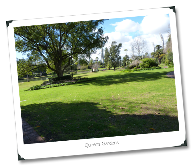
 Just over the Causeway is a lovely garden known as Queens Gardens. They were created in 1899 and this site was once a clay pit which was the source of the bricks for many of the early buildings. In the gardens are some swans and their cygnet.

 From Queens Gardens it is about a 20 minute walk into the central CBD. My feet were getting fairly tender, but mainly my left foot as my toes feels too squashed. It has taken 3.5 hours to walk into to Perth. Easily 3 hours if I hadn’t had a few detours and stops.
 I find by walking it is quite amazing how many different little things you get to notice that you don’t while driving. It would seem to be boring walking so much, but it isn’t. Little things happen all the time to increase the interest. For example on the journey home I was walking past St Mary’s Cathedral and I could hear some Handel music being played. I’m not a great lover of Classical music, but this sound good. I ducked into the cathedral and there was a group of young people involved in a rehearsel. Being played inside a large cathedral the music sounded glorious.
 I didn’t particularly enjoy the walk home. I found my left foot really hurting. I put on double socks. This helped for a while then I decided to try no socks on my left foot and that seemed to work well, but I did end up with a blister. One thing I did pass that was interesting was the Community Garden in Victoria Park, I believe a new venture, where people can have their own plot to grow stuff. A great idea. I found walking home along Albany Hyw that it was either car yards, eating places, a large number Indian restuarants and liquor outlets. There was also 4 hotels. There must be an enormous amount of money expended on alcahol. One section of Albany Hyw from Shepparton Rd to Leach Hyw is just an aweful dreary strip.
My walks have indicated that there are some beautiful areas and facilities around Perth. The cities looks so prosperous, but as Josh my son told me, we are rated as the third most unsustainable city in the world. Much of our wealth is based on mining. So any turn around there could have dramatic effects.
We have some beautiful parks along our river foreshores, but the reason some of them are there is because we treated the wet area along the river foreshores as areas to dump our rubbish, this was being done up until the 1980s. Some of the rubbish material now leaks into the river. Perth had many natural wetlands, but a large number were filled in as rubbish dumps, or converted to housing estates. I would hate to see what would happen if we had a really wet winter – but it won’t be this year!
I arrived home at 6.15pm. My feet rather sore. I need to see if I can change my shoes for some with more room for the toes. I spent about 1.5 hours in Perth before commencing the walk home. So my walk home was 3.5 hours.
The weather once again this Saturday magnificent. After a two hour walk and approximately 12 kilometres I made a slight detour to walk past my childhood home. The house was sold when I was 17. It is interesting to note how everything feels bigger when you look at the same scene as a kid.
From here to the Causeway was a little over an hours walk. My new shoes were irritating me a little, especially the left foot. It feels like I don’t have enough toe space.
As I walked over the Causeway to the CBD I detoured to walk around one end of Heirrison Island. Heirisson Island was named after French midshipman François-Antoine Boniface Heirisson, who was on the French ship Le Naturaliste which was a scientific expedition led by Nicolas Baudin between 1801 and 1804. The expedition made several journeys up the river from Fremantle in long-boats and made the first maps of the Swan River. The island was named in June 1801. The Causeway is two bridges that cross the Swan river and use Heirrison Island to join the bridges. On one end of the island is stature to remember Yagan who was killed in 1833 by two young farm hands in a treachorous way, Yagan’s head has only recently been returned to Australia after being kept in a British Museum. Unfortunately the stature of Yagan doesn’t look Aboriginal enough.
 |
| Yagan on Heirisson Island |
 |
| Yagan plaque |

My walks have indicated that there are some beautiful areas and facilities around Perth. The cities looks so prosperous, but as Josh my son told me, we are rated as the third most unsustainable city in the world. Much of our wealth is based on mining. So any turn around there could have dramatic effects.
We have some beautiful parks along our river foreshores, but the reason some of them are there is because we treated the wet area along the river foreshores as areas to dump our rubbish, this was being done up until the 1980s. Some of the rubbish material now leaks into the river. Perth had many natural wetlands, but a large number were filled in as rubbish dumps, or converted to housing estates. I would hate to see what would happen if we had a really wet winter – but it won’t be this year!
I arrived home at 6.15pm. My feet rather sore. I need to see if I can change my shoes for some with more room for the toes. I spent about 1.5 hours in Perth before commencing the walk home. So my walk home was 3.5 hours.
Wednesday, July 28, 2010
New Shoes
Went to the Athlete's Foot today, probably attracted to their computerised system of matching up your foot to a pair of shoes. The sales women also seemed to very quickly identify the type of shoe I would require. Most of my walking is urban, but I also wanted a shoe to do the Cape to Cape walk, but I didn't want a heavy hiking boot.
I was recommended a trail running shoe by ASIC. I haven't spent $190 on a pair of shoes before, but if they do the job and last 2 years I'll be happy. I also puchased a gel liner as this will increase the comfort and enable the shoe to last longer.
This video says something about the shoe, it seems I may have made the right purchase.
Saturday, July 24, 2010
McIver Station to Canning Bridge
This has been my longest walk today, but quite easy as all on good paving. I walked from McIver Train Station, last stop before Perth Station, over the Graham Farmer Freeway Bridge, then along the Burswood foreshore and then to South Perth. There are several interesting statues on the rivers edge in front of the Burswood Hotel. I stopped off at Mends Street Jetty opposite the City, for an expensive Cappuccino at $4.50, but they did a glass of iced water as well! From there I headed up to towards the Narrows Bridge, probably the narrowest part of the river.
Had a look at the Old Mill South Perth, first established in 1835, it is quite amazing that it has survived destruction, considering the amount of damage they have done in other parts of the city under the banner of development. The Mill wasn’t open until 1.00pm so I kept walking. This last stretch down to Canning Bridge where I first started the walk four Saturdays ago was not that pleasant as I had to keep company with a 6 lane freeway, something they got away with doing in the 60s, but wouldn’t be allowed today. Especially having a major freeway right on the edge of the river. I observed at least have a dozen different bird species, it is amazing how they survive so close to the hub bub of a modern city. As I crossed Canning Bridge I saw a dolphin and its calf moving up the river, my photo only shows the fin of the mother. This last stretch was a distant of over 15 to 18 kilometres. Fortunately the weather was cool, so it wasn't a particularly difficult walk. All up the walk around the river comes to about 55 kilometres and is now concluded, the Perth to Fremantle section at least.


Had a look at the Old Mill South Perth, first established in 1835, it is quite amazing that it has survived destruction, considering the amount of damage they have done in other parts of the city under the banner of development. The Mill wasn’t open until 1.00pm so I kept walking. This last stretch down to Canning Bridge where I first started the walk four Saturdays ago was not that pleasant as I had to keep company with a 6 lane freeway, something they got away with doing in the 60s, but wouldn’t be allowed today. Especially having a major freeway right on the edge of the river. I observed at least have a dozen different bird species, it is amazing how they survive so close to the hub bub of a modern city. As I crossed Canning Bridge I saw a dolphin and its calf moving up the river, my photo only shows the fin of the mother. This last stretch was a distant of over 15 to 18 kilometres. Fortunately the weather was cool, so it wasn't a particularly difficult walk. All up the walk around the river comes to about 55 kilometres and is now concluded, the Perth to Fremantle section at least.
Subscribe to:
Posts (Atom)